


Counting dirt has always been the hardest arithmetic on a civil job. A cut-and-fill balance is money. A stockpile is inventory. A monthly pay application is a claim about how many cubic yards moved between two dates. Traditionally, that number came from a crew walking the site with a rover, collecting shots on a grid, and building a surface from those points.
Drone photogrammetry changes the input, not the math. Here is what it is, what it measures well, and where the rules draw lines in Colorado.
What photogrammetry actually does
Photogrammetry is the practice of extracting measurements from photographs. The analogy: your two eyes see the same scene from slightly different positions, and your brain uses that offset to judge depth. A drone does the same thing with one camera, over and over. It flies a pre-planned grid and takes hundreds of overlapping photos, so every point on the ground appears in many images from different angles.
Software then matches common features across those images, solves for where the camera was at each shutter click, and computes a 3D coordinate for each matched point. The result is a point cloud — millions of X, Y, Z coordinates — which is meshed into a continuous surface model and draped with the photos to make an orthomosaic, a distortion-corrected aerial map you can measure on directly.
Volume comes from comparing surfaces. Subtract the surface flown today from the surface flown last month, or from the design subgrade, and the difference is cut and fill. Same calculation a surveyor has always run. The difference is point density: a photogrammetric surface may carry thousands of points where a walked grid carried dozens.

How accurate is it
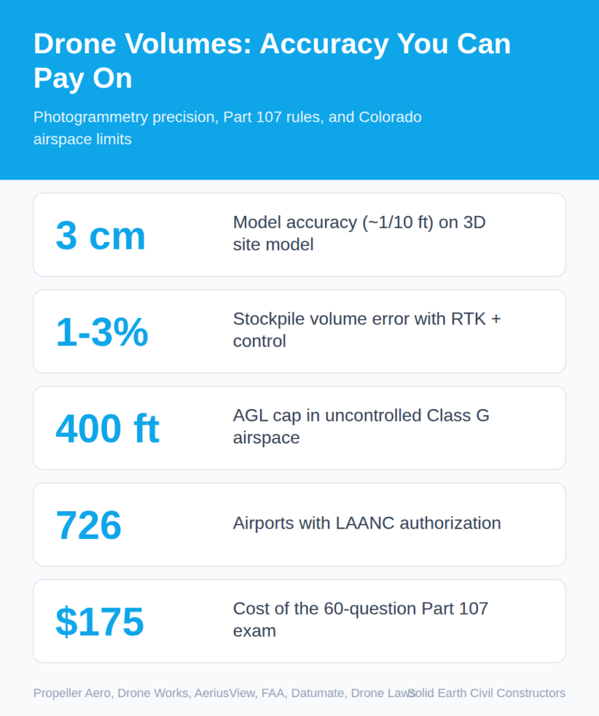
Accurate enough to pay on, with conditions. Geo-referenced drone imagery processed with photogrammetry can produce a 3D site model with measurements accurate to roughly 1/10 ft — about 3 cm — letting quarry and construction teams measure stockpiles without traversing them on foot (Propeller Aero). On volume specifically, with RTK positioning — real-time kinematic GPS, which uses a fixed base station to correct the drone’s position to centimeter level — and a checked ground control network, industry-reported accuracy for a well-flown stockpile survey typically lands in the 1–3% range, which is workable for both progress reporting and inventory reconciliation (Drone Works). Other providers quote 2–5% accuracy compared with traditional methods, with a site flown in under an hour and volumes returned within one to three business days, and surfaces compared over time to track progress, calculate cut/fill, and verify contractor quantities (AeriusView).
Note the qualifiers. “Well-flown.” “Checked ground control.” Photogrammetry measures surfaces it can see. It does not see through standing water, dense vegetation, or the underside of a haul truck parked on the pile. Those are real limits, not footnotes.
The rules that govern the flight
A drone over an active construction site is a commercial aircraft operation. Federal law applies.
- Part 107 is the governing rule. 14 CFR Part 107 covers commercial operation of small unmanned aircraft under 55 pounds in the National Airspace System. It took effect in August 2016 and applies to any drone survey data collection — whether the pilot is an employee, a subcontractor, or a third-party service provider (Datumate). Any commercial use, including construction inspections and land surveys, requires FAA drone registration and a certificated remote pilot (Rupprecht Law).
- Someone has to be certified. To operate the controls you need a remote pilot certificate with a small UAS rating, or you must be under the direct supervision of someone who holds one. Minimum age is 16. You qualify by passing an initial aeronautical knowledge test at an FAA-approved testing center, or — if you already hold a Part 61 pilot certificate with a flight review in the previous 24 months — by completing an FAA online training course (FAA). The knowledge test is 60 multiple-choice questions and costs roughly $175, and certificates run 24 months before recurrent training (Datumate).
- Keep it in sight. The aircraft must remain within visual line of sight of the remote pilot or a designated visual observer for the entire flight (Datumate).
- Check the airspace before you check the weather. In Colorado, flights in controlled airspace — Class B, C, D, and surface Class E around airports — require prior FAA authorization through LAANC or FAA DroneZone. In uncontrolled Class G airspace, flights are capped at 400 feet above ground. LAANC is available at 726 airports; where it is not, operators use the manual authorization process (Drone Laws).
Two Colorado-specific wrinkles
First, procurement. A CDOT design bulletin states that effective Dec. 22, 2025, Federal Highway Administration funds may no longer be used to procure, operate, or maintain UAS equipment — aircraft, flight controller, camera, or ground control station — manufactured by covered foreign entities. This applies to all federal-aid projects in Colorado, including local agency projects receiving federal aid pass-through (CDOT Design Bulletin 2026-2). If your project touches federal money, the hardware on the shelf matters as much as the pilot holding it.
Second, licensure. A drone does not make anyone a surveyor. In Colorado, individuals offering or practicing land surveying must hold an active license, and survey documents must bear the seal and signature of the actively licensed Colorado professional land surveyor in responsible charge of the work (Colorado State Board of Licensure). A drone-derived quantity used for progress tracking is a construction management tool. A boundary or a sealed survey document is a licensed act. Keep those categories separate and the exposure stays clean.
The agency case
CDOT has tested unmanned aerial systems for survey data collection in Grand Junction, with the stated aim of improving accuracy and worker safety relative to sending employees or contractors into the field to gather traffic counts, road measurements, and other pre-construction data with traditional equipment (CDOT). The department also uses drones for traffic control, construction, and environmental surveying, including geohazard investigation to detect rock slides near roadways (Colorado Legislative Council).

The safety argument is the underrated one. Every stockpile measured from the air is a person not climbing a loose slope with a rod.
Where this fits with machine control
Drone data and 3D machine control solve different halves of the same problem. Machine control puts the design surface in the operator’s cab and guides the blade in real time. Photogrammetry measures what the blade actually left behind. One directs the work; the other verifies and quantifies it. At Solid Earth, 3D machine control and GPS grading have been standard across our fleet since 2015, and the value of an as-built surface is exactly that it can be checked against the design the machines were driving to.
The workforce is moving in the same direction. The FAA’s Aerospace Forecast projects 472,269 certified remote pilots by 2028 — more than 103,000 above 2023 levels (Drone U). Aerial measurement is becoming a normal line item, not a novelty.
Evidence supports the volume numbers within the stated tolerances and flight conditions. It does not support treating a point cloud as a substitute for a licensed survey, or for eyes on the subgrade. Use it for what it measures.
Have a project in mind? Start the conversation with Solid Earth.
Images are presented for illustration purposes only.We use real photographs when we need to show what was happening at a real event.
About the Author: Solid Earth

Related Posts


Recent Works